Languages
BR-319
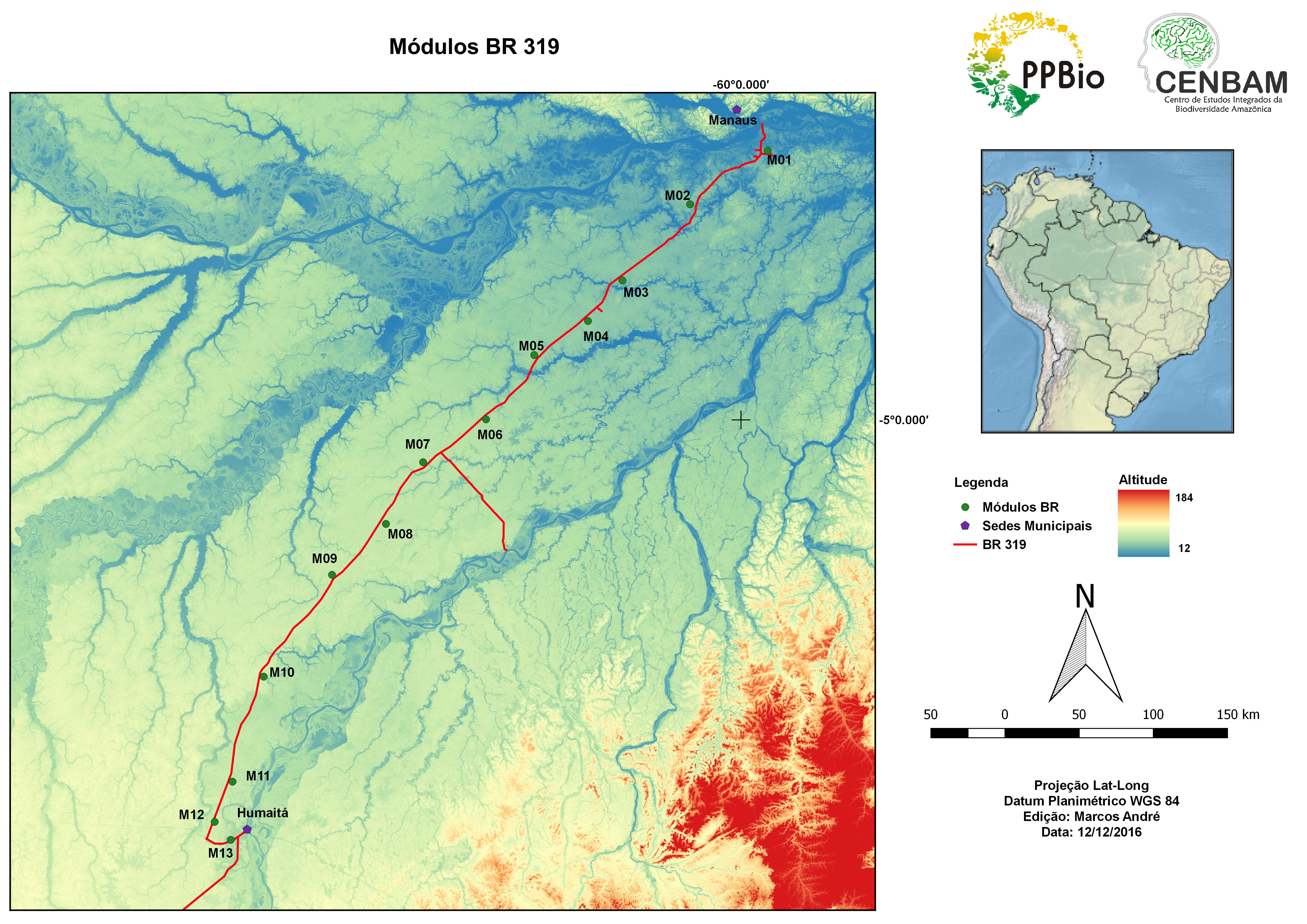
These modules aim to obtain basic data about the distribution of biodiversity along this highway. This information can be used for land use planning, monitoring and evaluation of the environmental impacts of the BR-319. The imstallation of modules is faster than full grids and allows for greater spatial comprehensiveness. So far, there are 14 modules along the 700km highway between Manaus and Humaitá, 11 are active and 3 have been disactivated (KM83, KM158 and KM820).
INFRASTRUCTURE AND ACCESS to the modules.
Soil, Geomorphology and Vegetation
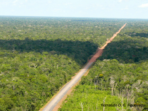
Subtle gradients of soil and topography intersect the Purus-Madeira interfluvial in the Northeast-Southwest direction (IBGE, 1997). In the north, the vegetation present along BR -319 is dense ombrophilous lowland forest. To the south, closer to the municipalities of Humaitá and Porto Velho, this changes to open ombrophilous lowland forests (IBGE, 1997). The geomorphology of the region is characterized by the occurrence of large tabular interfluvilas with very flat topography (Brazil, 1978) and altitudes that vary between 30 and 50 m (IBGE, 1997).Modules up to 260 km from Manaus are in a relatively young paleo-várzea deposited by the Amazon / Solimões River, between 7,000 and 27,000 years ago (Costa et al., 2001, Rosetti et al., 2005). The presence of a micro-relief with variations of altitude between 1 and 3 m is quite frequent and favors the formation of temporary ponds. The presence of large amounts of litter and fine roots on the soil, similar to that found in podzolic soils of the northern channel of the Amazon River, is also a striking feature of the region, despite the silty soil. The soil is mainly of the hydromorphic laterite type and in terraces and fluvial plains Hydromorphic Glycemic and Alluvial Eutrophic or Alic soils occur (Quesada et al., 2011).
Fluviometric and rainfall stations
The link below contains files with information on all the fluviometric and rainfall stations in the surrounding area of the BR-319 (including some stations outside the Purus-Madeira interfluvial). The source of the data is Hidroweb. The .xls table shows the duration of the historical rainfall series and the river quota around our study area and the maps show the location of these stations (figures can be seen in ppt). The shapefile (rar file) compiles the two information: location and duration of the series. In the table it is possible to identify the station of interest see the code of the station and with that number download the data in the website of Hidroweb. The compilation of the database was made by Rafael Stern, who was a scholar of the PPBio sub network Manaus. Download here the archives of the fluviométricas and pluviométricas stations. Any doubts or inconsistencies found in the database, please contact: gestaoppbio.ne@gmail.com.
Financing
The BR319 research modules began to be established in 2004, with resources from the projects "Study of the beta diversity of a plant community along the Purus-Madeira interfluvial to determine priority areas for conservation", Case 542/04 Fapeam granted to Flavia Costa and "Diversity and distribution of palm trees (Arecaeae) in relation to environmental gradients along the BR-319, Purus-Madeira interlaced, AM", Process 0715_20061 of the O Boticario Foundation for Nature Protection, granted to Thaise Emilio / Flávia Costa. At this stage, modules were established in KM 83, 158, 220 and 260. The KM 83 and 158 modules were disabled due to logistical difficulties.
Two new modules have been installed to replace the deactivated ones at the start of the BR319: on the KM34 and KM100. All of the 8 new modules (KM34, KM100, KM300, KM350, KM400, KM450, KM540 and KM620) were financed mainly with resources from Project PRONEX -FAPEAM / CNPq no. 16/2006 entitled "Biodiversity mapping and monitoring of ecosystem processes for scientific inclusion of rural communities along BR 319 in the State of Amazonas "granted to William Magnusson. This project also carried out maintenance on the installation of infrastructure in modules 220 and 260. PRONEX allowed the consolidation of several research initiatives along the BR 319.
The module, now deactivated, of the KM820, near Porto Velho, was established and collected with resources from the FINEP / GEOMA project, "Modeling the Diversity of the Madeira-Purus Interflux: Natural Assets and Anthropic Impacts" granted to Mário Con-Haft. The collection of data in the modules has been or is being financed by the projects listed below in chronological order:
- “Study of the beta diversity of a plant community along the Purus-Madeira interfluvium to determine priority areas for conservation”, Process 542/04 Fapeam. Coordinator: Flávia Costa
- “Diversity and distribution of palm trees (Arecaeae) in relation to environmental gradients along the BR-319, Purus-Madeira, AM interfluvium”, Process 0715_20061 of the O Boticário Foundation for Nature Protection. Coordinator: Flávia Costa
- "Biodiversity survey planning and monitoring of ecosystem processes for scientific inclusion of rural communities along BR 319 in the State of Amazonas", PRONEX Project - FAPEAM / CNPq no 16/2006. Coordinator: William Magnusson
- “Modeling the diversity of the Madeira-Purus Interfluvium: natural assets and human impacts” project FINEP / GEOMA. Coordinator: Mario Con-Haft
- Hydrology and Vegetation in the Purus-Madeira Interfluvium: an Integrated Approach to the Mapping of Biomass and Resources - Edital Universal CNPq 2009 - Coordination Dr. William E. Magnusson
- Structuring relationships between hydrology and vegetation in the Purus-Madeira interfluvium - Fapesp / Fapeam announcement - Coordination Dr. Javier Tomasella and Dra. Flávia Costa, FAPEAM / FAPESP, Process 006/2009
- Ecological and historical factors in the evolution of the Amazonian biota: molecular and phenotypic variation of species and biological communities in the western Amazon - Edital FAPEAM / CNPq 003 / 2009– Coordination Dr. Albertina P. Lima
- Purus Madeira Initiative (project financed by DINIT that will meet some of the mitigation actions provided for in BR 319 EIA-RIMA)
- Isotopic characterization (δ2D / δ 18O) of the BR 319 area of influence: hydrological and geochemical implications - Edital MCT / CNPq / FNDCT - Coordination Dra. Françoise Yoko Ishida.
Click on the link to learn more about PRONEX - Support Program for Centers of Excellence.
References:
Brasil. 1978. Projeto RADAMBRASIL. Folha SB.20 Purus; geologia, geomorfologia, pedologia, vegetação e uso potencial da terra (ed Mineral, D.N.P.), Vol. 17. p. 566.
Costa J.B.S., Lea Bemerguy R., Hasui Y., Da Silva Borges M. Tectonics and paleogeography along the Amazon river. 2001. Journal of South American Earth Sciences 14(4):335-347.
IBGE. 1997. Recursos naturais e meio ambiente: uma visão do Brasil. Instituto Brasileiro de Geografia e Estatística. 2. ed. 208 p.
Quesada, C.A., Lloyd, J., Anderson, L.O., Fyllas, N.M., Schwarz, M., and Czimczik, C.I. 2011. Soils of Amazonia with particular reference to the RAINFOR sites. Biogeosciences 8: 1415–1440. doi:10.5194/bg-8-1415-2011.
Rossetti, D. F., Toledo, P. M. de & Góes, A. M.. 2005. New geological framework for Western Amazonia (Brazil) and implications for biogeography and evolution. Quaternary Research 63: 78-89.
A identificação de cada módulo é feita por uma chave mista que inclui um número, um nome fantasia e uma quilometragem. Cada módulo recebe um número de acordo com a sua posição em relação a Manaus. O módulo mais próximo recebeu o nome de M01, o próximo de M02 e assim por diante até M11 próximo a Humaitá. O nome fantasia é dado pelo rio mais próximo ao módulo. E a quilometragem é a quilometragem aproximada medida a partir do início da BR-319 na Bola da Suframa (Manaus). Atualmente, a base ativa da BR-319 consta de 11 módulos e as informações sobre cada módulo podem ser acessados abaixo:
- M1-PURUPURU-Km34;
- M2-MANAQUIRI-Km100;
- Infraestrutura M3-TABOCA-Km168;
- M4-TAQUARA-Km 220;
- M5-IGAPO-AÇU-Km260;
- M6-ORQUESTRA-Km300;
- M7-RIO NOVO-Km 350;
- M8-CAPANÃ-Km 400;
- M9- JARI-Km450;
- M10 – ARACÁ-Km540;
- M11-PURUZINHO-Km 620.
- Modules 12 and 13
The km 83, 158 and 820 modules are disabled, but information about them can be accessed at the links below:
Download the Official SIG BR-319 here, including the official name and position of the parcels
Metadados
Guidelines to facilitate the search in the repository: in the search page of the link above enter the keyword: BR 319
Contact
Dr. William E. Magnusson
Coordenação de Pesquisas em Ecologia (Ecology Research Coordination)
Instituto Nacional de Pesquisas da Amazônia
bill@inpa.gov.br
PPBio Portal was developed by the management team of Data Repository PPBio/CENBAM · Copyright © 2012 · All rights reserved
2.936 André Araújo AVE - Petrópolis - Zip Code 69060-001 - Manaus-AM-Brasil
Post Box: 2223
