Languages
Infraestrutura Módulo KM 400
The M08 is located in the Lago do Capanã Grande Extractive Reserve and is a federal conservation unit in Brazil categorized as an extractive reserve, created by Presidential Decree on June 3, 2004 in an area of 304,146 hectares in the state of Amazonas. Authorization is required for the collection of scientific material: www.icmbio.gov.br
Access
The M08 module is located in the most central region of BR-319, making it difficult to access it either from Manaus or from Humaitá. In the rainy season (November to May) the trip becomes a great adventure, because besides the dangerous holes and bridges there is a lot of mud and a suitable 4x4 vehicle with flat tires and winch is crucial to avoid major complications. Departing from Manaus, the ferry crosses from CEASA to the municipality of Careiro da Várzea, which costs R $ 25.00 (ferry from Ceasa). From Careiro da Várzea to the city of Careiro (better known as Castanho) are 100 km of asphalt in good condition. The city of Castanho is the last place where it is possible to get fuel, ice and food, buy some field material, make connections, etc. in this place, although a bridge is being built, there is also a ferry crossing that costs R $ 10.00 (ferry from Castanho). From there, there are another 75 km of road, mixing stretches of good and bad conditions to Vila do Tupana, where there is another ferry crossing also for R $ 10.00 (Tupana ferry). The next section, with about 80 km, connects Tupana to Igapó-açú and is in very bad condition with a very deteriorated asphalt and many deep holes. A plan by the Brazilian Army to repair the two ends of the BR-319 is underway, the part from Careiro da Várzea to Igapó-açú, with about 250 km, and the part from Humaitá to Vila de Realidade, about 150 km. However, the current road conditions are described above and can be consulted on the DNIT website.
Vila de Igapó-açú is the last place where there is still some trade (Mr. Raimundo on the right and Pingo on the left are the owners of the main businesses where, sometimes, there is nothing to buy) and it is also the place of the last crossing ferry in the amount of R $ 10.00 (ferry from Igapó). From this point on, the BR-319 lives up to its reputation as an abandoned highway and becomes really uninhabited. The last point of support is the home of D. Maria and Sr. João, 45 km after Igapó-açú, a very friendly and helpful elderly couple. This point is km 300 of the BR, where the M06 is coincidentally located. From this point to the M08, it is another 100 km, mixing small stretches of asphalt in good condition with many dangerous stretches of mud, holes and bridges in a precarious state. Mr. Nonato, a resident of Igapó-Açu, is responsible for maintaining the bridges on this stretch. At km 337 the old entrance to the city of Manicoré is located and at km 325 there is a buffalo farm (Mr. Augusto) that is responsible for the maintenance of the bridges on this stretch. It is good to ask the conditions of the bridges on this farm, because 12 km before the M08 there was a bridge in very bad condition. The Rio Jutaí is located 21 km before the M08.
Conditions of the trails and camps
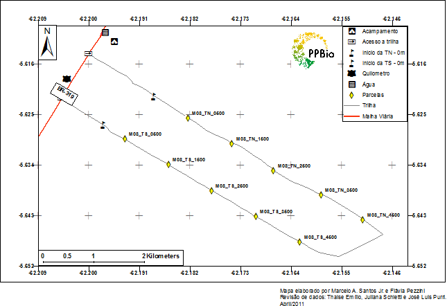
The M08 camp is located on the left side of the highway (towards Humaitá) very close to km 400, after two small bridges in sequence and in front of a manhole pond, where it is also the place for bathing and collecting water. It is highly recommended to use GPS loaded with the proper coordinates. The camp is located approximately 150 m from the left bank of the road (towards Humaitá) and there is a small entrance for vehicles. The TN entrance is about 400m south of the camp (towards Humaitá) and there is a clearing in the first 1.5 km of the trail, being necessary to cross it to access the zero point. At 800 m from the side of the road there is a fork in the TN, on the left it leads out of the module and moving forward is the clearing. TN is 6.5 km in total. The TS entrance is 1 km south of TN, has a P (-) portion 500 to 500m from the roadside and the zero point is 950m from the roadside. It has 6 km in total.
What's nearby
Practically nothing. The nearest EMBRATEL tower is Jorge Brasil and is 5.5 km south of the camp. The Jutaí River is 21 km north of the camp.
Where to get water
There is no well in this module. The water available for bathing and cooking is collected in the igarapé that forms the manhole lagoon. To cook it is necessary to carry the water from the stream to the camp and it is recommended to treat it with hypochlorite or equivalent. The stream is perennial, but adjustments are needed, according to the water levels, on the board used for the bath.
Local staff
Do not exist. Any field assistants that are needed should be provided in the city of Castanho, as there are no residents nearby. The area is frequented by fishermen and hunters.
Safety
BR-319 is commonly used as a route by different walkers, which can be malicious. Thus, it is recommended for these excursions to the central part of the highway, larger groups that can inhibit an eventual malicious approach and always leave one or more people, such as: the cook, watching the camp during the incursions to the module.
If you need help
It is extremely preventive to keep a vehicle in place, because in the event of a more serious incident, there is nowhere or how to turn to help. There are phones in the EMBRATEL towers, but they are usually locked or inoperable. The closest tower is Jorge Brasil 5.5 km south of the M08 camp.
Term of commitment and rules of conduct
Before going to the field, you must download, read and sign the Term of Commitment and Standards of Conduct of BR-319 and send it to the PPBio Management at email gerencia.ppbio@gmail.com.
Download the official GIS with all points along BR-319: Shapefiles Modules BR-319
Contact
Gerência PPBio
Coordenação de Pesquisas em Ecologia
Instituto Nacional de Pesquisas da Amazônia
PPBio Portal was developed by the management team of Data Repository PPBio/CENBAM · Copyright © 2012 · All rights reserved
2.936 André Araújo AVE - Petrópolis - Zip Code 69060-001 - Manaus-AM-Brasil
Post Box: 2223
