Languages
Infrastruture KM 620 Module
Access
The M11 module is more easily accessed from Humaitá, a city of 40,000 inhabitants, 770 km from Manaus and 210 km from Porto Velho, which has several shops, where it is possible to purchase basic field material. The Manaus-Porto Velho flight ticket costs, on average, R $ 150.00. The bus from Porto Velho to Humaitá costs around R $ 70.00. In Humaitá it is possible to support the staff of UFAM and the Cenários Project, but the contacts must be consulted in advance. Departing from Porto Velho, it is about 200 km to Humaitá, being necessary to cross the Madeira River by ferry (R $ 6.90 per car). From Humaitá to the Lábrea interchange there are 30 km of road recently recovered by the army. Entering BR-319, the M11 module is 42 km from the Lábrea interchange and about 70 km from this interchange is located the village of Realidade, where it is possible to have a snack and find out information about the road. The M11 module camp is located on the right bank (towards Humaitá-Manaus) and is accessed between two small lagoons (km 620 of BR-319). Departing from Manaus, the same route is made until reaching the M09 (access the description of this module on the PPBio page). From the M09 to the M11 there are over 170 km of bad road, with complicated puddles and many holes. However, bridges are better and more reinforced. On this stretch of BR-319, the “Catarino” farm is located, a family of migrants who remained in the region after abandoning the highway, which carries out the maintenance of bridges and transmission lines for EMBRATEL. They are helpful to travelers and can provide any assistance.
Conditions of the trails and camps
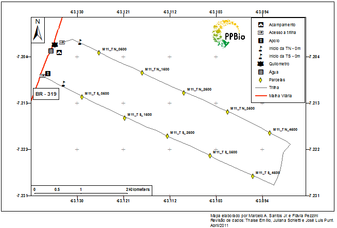
It is highly recommended to use GPS loaded with the proper coordinates. The tracks in this module are in the PPBio standard, with plots and zero points at the correct distances. The TN entrance is 400 m north of the camp (towards Humaitá-Manaus) and the TS entrance 600 m south of the camp, right next to the EMBRATEL José Moreira tower.
What's nearby
Almost anything. The nearest EMBRATEL tower is José Moreira, located 600 m south of the camp. There is a more intense traffic of people in this region, but local residents are scarce and unknown by the researchers.
Where to get water
There is no well in this module. The water available for bathing and cooking is collected in the lagoon on the other side of the road (50 m from the camp). To cook it is necessary to carry the water from the pond to the camp, and it is recommended to treat it with hypochlorite or equivalent. It is also possible to use the well of an abandoned house near the José Moreira tower. However, no contact was made with possible residents and we are not allowed to use it. This region has a higher number of dry months and the use of water from unauthorized locations can lead to conflicts.
Local staff
Do not exist. Any field assistants who are needed should be provided in the city of Humaitá or Castanho, as there are no permanent residents nearby.
Safety
BR-319 is commonly used as a route by different walkers, which can be malicious. Thus, it is recommended for these excursions to the central part of the highway, larger groups that can inhibit an eventual malicious approach and always leave one or more people, such as: the cook, watching the camp during the incursions to the module.
If you need help
It is extremely preventive to keep a vehicle in place, because in the event of a more serious incident, there is nowhere or how to turn to help. There are phones in the EMBRATEL towers, but they are usually locked or inoperable. The nearest tower is José Moreira, 600 m south of the M11 camp. In case of emergency, the nearest hospital is Humaitá. At km 590 there is the village Realidade which has a health post.
Term of commitment and rules of conduct
Before going to the field, you must download, read and sign the Term of Commitment and Standards of Conduct of BR-319 and send it to the PPBio Management at email gerencia.ppbio@gmail.com.
See the maps and topographic profile of the module
Download the official GIS with all points along BR-319: Shapefiles Modules BR-319
Contact:
Gerência PPBio
Coordenação de Pesquisas em Ecologia
Instituto Nacional de Pesquisas da Amazônia
PPBio Portal was developed by the management team of Data Repository PPBio/CENBAM · Copyright © 2012 · All rights reserved
2.936 André Araújo AVE - Petrópolis - Zip Code 69060-001 - Manaus-AM-Brasil
Post Box: 2223
