Languages
Anavilhanas Archipelago
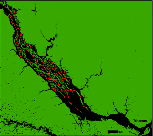
The Anavilhanas site is a virtual grid consisting of 3 km equidistant lines drawn on a 1: 900,000 m georeferenced image of the Anavilhanas archipelago. The locations where this grid crosses islands, indicates where to place a sampling unit. Thus, 84 sample units have been defined which are transects that cross the islands perpendicular to their length. The transects were always arranged perpendicularly to the island in order to cover the topographic gradient that goes from the edge to the interior of the islands. All transects were georeferenced and marked out by labels at the beginning of each trail.
The Anavilhanas archipelago is one of the largest river archipelagos in the world with more than 400 islands that vary according to the water level of the river. The water level varies by up to 10 meters between ebb and flood periods, with high water from October to March and is low from April to September. The archipelago is part of a federal conservation unit that has recently been changed from the category of Ecological Station to National Park, incorporating public use into its management plan. The Anavilhanas National Park, located on the Rio Negro about 40 km above the city of Manaus, is administered by ICMBio (Chico Mendes Institute for Biodiversity Conservation), headquartered in the municipality of Novo Airão. Within the archipelago there are two floating and one terrestrial base to support inspection and research. These structures are located near Lago do Prato, the Baipendi river and at the mouth of the Apuaú river.
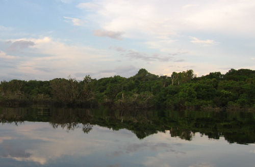
The islands are elongated with a side of deposition of material coming from the Branco River and a ravine region excavated by the waters of the Negro river. Because they are bathed by black water the islands have a type of forest known as igapó. The igapó is characterized by presenting soggy and excessively acid soil with abundant decomposing organic matter. The physiognomy of the vegetation of the islands varies according to their size. The larger islands have, on average, three strata, with tall trees, without tortuosities; The upper stratum have trees of approximately 25 m and emergent above this limit. The smaller islands generally have lower vegetation which are subject to being fully submerged during the flood.
Logging Research
Some tree species present in the islands are widely used in the light wood market, for the production of plywood and in construction. The fact that these trees are present in large quantities in the area and the archipelago is close to Manaus, the main consumer market, has led the Anavilhanas archipelago to be illegally exploited for decades. Due to the history of illegal logging in the region and the difficulty of inspection, the environmental analysts Chico Mendes Institute for Biodiversity Conservation (ICMBio) considered the control of these activities as the main challenge to maintain the integrity of the Conservation Unit and therefore requested the Researchers to conduct a project to collect data on the spatial distribution of the most exploited species and illegal exploitation and on the effects of exploitation on the populations of these species. This study gave rise to the virtual research grid in Anavilhanas.
Metadata
METACAT SERVER Search for Anavilhanas
Contact
Dr. William E. Magnusson
Coordenação de Pesquisas em Ecologia
Instituto Nacional de Pesquisas da Amazônia
PPBio Portal was developed by the management team of Data Repository PPBio/CENBAM · Copyright © 2012 · All rights reserved
2.936 André Araújo AVE - Petrópolis - Zip Code 69060-001 - Manaus-AM-Brasil
Post Box: 2223
