Languages
PPBio Grids and Modules
On the scale of the Amazon basin (or of the country or state), each grid is a sampling unit, and the units of sampling are smaller sub-units. For long-term ecological studies within the same site, there are spatially explicit standardized modules that allow comparisons within and between grids. Not all organisms can be efficiently sampled at the same sampling unit. However, the greater the number of taxa sampled within the same sample unit, the more comparisons can be made, and the greater the chance of finding biodiversity substitutes (surrogates) with a viable cost-benefit ratio. In addition, many of the groups with economic potential for the pharmaceutical industry (including fungi, bacteria, viruses, and insects that concentrate plant secondary compounds) are often closely associated with higher organisms, such as woody plants or vertebrates. Only integrated studies can reveal their interactions and allow the assessment of the economic value of extractive industries.
Predictive variables, such as soil characteristics, water chemistry and vegetation structure, may be recorded as standardized modules, making it unnecessary for every researcher invest time and money to obtain the same data. Since collecting predictive data variables (e.g. chemical analysis of soil) is often more costly than collecting specimens, reducing such duplication of effort can lead to financial savings orders of magnitude greater than the simple amount of time that is saved. Reducing duplication of effort can also be important for professionals involved in the management of parks and reserves. Although methods for collecting environmental data (e.g. soil samples, leaf-litter collection, measures of all plants in a given small area) typically provides only a small impact, multiply that impact by the number of researchers using the site, and the potential impact could be great indeed. Consequently, avoiding data collection duplication also benefits the management of parks and reserves.
For these reasons, researchers defined a series of standard modules that can be used for specific groups of organisms. Other modules may be included in the future as the demand arises, but to-date all organisms investigated within the PPBio grids could be efficiently studied with one of the following modules:
1 Terrestrial Plots: plots systematically distributed along the grid, appropriate for estimates of biomass (woody flora to microbes), the majority of terrestrial invertebrates, small vertebrates and most of the flora.
2 Aquatic Plots: plots in watercourses - suitable for studies of fish, crustaceans, aquatic insects and aquatic vegetation.
3 Riparian Plots: plots along the edge of waterways, suitable for riparian and aquatic species that are not vegetation but are closely associated with water courses (e.g. frogs, snakes, fish and tadpoles in puddles).
4 Trails: suitable for vertebrates medium and large transects, and rare plants. May also be useful for studies of genetic variation within a grid.
These modules have proven effective for habitats as diverse as Pantanal floodplains, and savannas and tropical forests in Amazonia. Given the success of its application in these environments, it is likely that these modules will be effective in most terrestrial or semiterrestrial ecosystems. The sampling scheme has not yet been tested on lowland floodplains, coastal and marine areas. However, the sample design with trails and permanent plots with a constant altitudinal component (i.e. depth) could be used to sample the great biodiversity in aquatic ecosystems (including marine ecosystems). Only the mode of transport and sampling instruments would need to be modified.
Efficiency in large projects
To achieve a more efficient outcome when monitoring environmental impacts of large projects (logging, hydroelectric dams and others), and to ensure that such monitoring is conducted across the widest possible variety of biodiversity components and ecosystem processes, we recommend the following module:
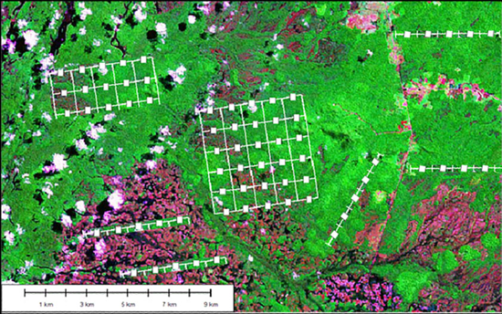
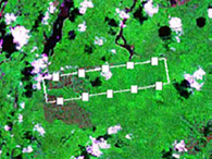
Two parallel trails 5 Km 1 Km from each other, with uniformly distributed plots and a variable number of aquatic and riparian plots, as shown in the figure below:
